Rockton Aerodrome Weather Briefing
Page generated at:
Sat Mar 28 19:56:22 UTC 2026
Sat Mar 28 15:56:22 EDT 2026
For soaring conditions, visit XCSkies or SkySight
For the tephigram, visit Tephigrams
For a map of NOTAMs, visit NOTAM Map
Nobody wants the source code to this
Kitchener - Cambridge - Region of Waterloo.
Tonight..Clear. Becoming partly cloudy this evening. Wind west
 20 km/h gusting to 40 becoming light this evening. Wind becoming
 southwest 20 late this evening. Low minus 2. Wind chill near
 minus 8.
Sunday..Mainly sunny. Wind becoming southwest 30 km/h in the morning.
 High 9. Wind chill minus 7 in the morning. UV index 5 or moderate.
Sunday night..Clear. Becoming partly cloudy before morning. Wind
 southwest 30 km/h becoming light near midnight. Low zero.
Environment Canada weather for Hamilton:
City of Hamilton.
Tonight..Partly cloudy. Wind west 20 km/h gusting to 40 becoming
 light late this evening. Low minus 3. Wind chill near minus 8.
Sunday..Mainly sunny. Wind becoming southwest 20 km/h gusting to 40
 in the morning. High 9. UV index 5 or moderate.
Sunday night..Clear. Increasing cloudiness before morning. Wind
 southwest 20 km/h gusting to 40 becoming light in the evening. Low
 plus 1.
METARs and TAFs for Waterloo, Hamilton, London and Toronto:
Waterloo Well , Canada (CYKF) 43-28N 080-23W
Mar 28, 2026 - 03:00 PM EDT / 2026.03.28 1900 UTC
Wind: from the W (270 degrees) at 16 MPH (14 KT) gusting to 24 MPH (21 KT) (direction variable):0
Visibility: 9 mile(s):0
Sky conditions: mostly cloudy
Temperature: 32 F (0 C)
Windchill: 21 F (-6 C):1
Dew Point: 12 F (-11 C)
Relative Humidity: 43%
Pressure (altimeter): 30.47 in. Hg (1031 hPa)
ob: CYKF 281900Z AUTO 27014G21KT 220V310 9SM BKN042 00/M11 A3047 RMK SLP335
cycle: 19


Hamilton Airport , Canada (CYHM) 43-10N 079-56W
Mar 28, 2026 - 03:00 PM EDT / 2026.03.28 1900 UTC
Wind: from the WSW (250 degrees) at 18 MPH (16 KT):0
Visibility: 15 mile(s):0
Sky conditions: mostly cloudy
Temperature: 33 F (1 C)
Windchill: 21 F (-6 C):1
Dew Point: 17 F (-8 C)
Relative Humidity: 50%
Pressure (altimeter): 30.48 in. Hg (1032 hPa)
ob: CYHM 281900Z 25016KT 15SM SCT045 BKN050 01/M08 A3048 RMK CU3SC4 SLP337
cycle: 19


London, Ont., Canada (CYXU) 43-02N 081-09W 278M
Mar 28, 2026 - 03:00 PM EDT / 2026.03.28 1900 UTC
Wind: from the W (260 degrees) at 8 MPH (7 KT) gusting to 18 MPH (16 KT) (direction variable):0
Visibility: 15 mile(s):0
Sky conditions: mostly clear
Temperature: 33 F (1 C)
Windchill: 26 F (-3 C):1
Dew Point: 15 F (-9 C)
Relative Humidity: 47%
Pressure (altimeter): 30.51 in. Hg (1033 hPa)
ob: CYXU 281900Z 26007G16KT 220V310 15SM FEW047 01/M09 A3051 RMK SC1 SLP347
cycle: 19


Toronto Pearson Int'L. Ont., Canada (CYYZ) 43-40N 079-38W 173M
Mar 28, 2026 - 03:00 PM EDT / 2026.03.28 1900 UTC
Wind: from the W (280 degrees) at 21 MPH (18 KT):0
Visibility: 15 mile(s):0
Sky conditions: mostly cloudy
Temperature: 33 F (1 C)
Windchill: 21 F (-6 C):1
Dew Point: 14 F (-10 C)
Relative Humidity: 43%
Pressure (altimeter): 30.47 in. Hg (1031 hPa)
ob: CYYZ 281900Z 28018KT 15SM BKN050 01/M10 A3047 RMK SC6 SLP329
cycle: 19
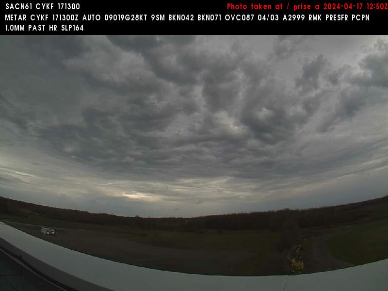
Waterloo Webcam (SOSA is on the horizon)
Satellite images:
Graphical Area Forecasts:
Current:

6 hour forecast:

12 hour forecast:

Precipitation radar:
Canadian:

American:


Latest Satellite Images
Visible:

Visibility:

Infrared (Temp):

Water Vapour:

Forecast Surface Conditions


If these images do not load, you need to get a cookie from Dr. Jack.
This Day:


Next Day:


Day After:


